
Who Wrote the Zena Halpern Map
I propose the Zena Halpern Map is a treasure map drawn by French Admiral Jean-Baptiste du Casse. The Admiral used French to draw the Map for his son-in-law Louis de La Rochefoucauld, Marquis de Roye. The Marquis de Roye was a lieutenant-general of the galleys in the French Navy who served with Admiral du Casse and was highly thought of by the Admiral. Admiral du Casse was a colorful character who lived from 1646 to 1715. Some of Admiral du Casse's exploits are documented in The Pirate Hunter: The True Story of Captain Kidd, Admirals of the Caribbean and L'Amiral du Casse.
Admiral du Casse took part in numerous raiding parties that included the port city Cartagena, Columbia, Port-Royal in Jamaica (after a devasting earthquake), St. Christopher's(St. Kitts) and Surinam. Admiral du Casse was also one of the leaders of the 1711 Spanish Treasure Fleet. The raids he participated in enriched him and his family. The Admiral may have diverted some of his riches to Oak Island during a return trip to France or Spain from the Caribbean.
Admiral du Casse and lieutenant-general Rochefoucauld took part in the Battle of Santa Marta in 1702. The admiral was so impressed with his junior officer that he introduced him to his daughter when they returned to France and two years later they were married.
It appears that Oak Island may have been a stopping point on Admiral du Casse's return trips to Europe from the Caribbean. Oak Island is off the coast of Nova Scotia and may have been the last chance to stock up on fresh water and other supplies before the Transatlantic crossing which Admiral du Casse made numerous times.
Interpreting the Zena Halpern Map The Map has very little information on it to help locate the treasure deposited by Admiral du Casse but, all the information contained on the map was relevant to finding it. The map shows the layout of Oak Island and a couple of nearby Islands that are crucial to decoding the location of the possible hidden treasure. With the little information available on the Halpern Map it may be possible to find the magic spot to locate the possible buried treasure.
Mnemonics Used on the Zena Halpern Map Everything written on the Zena Halpern Map had some meaning to be used to help find the buried treasure. The terms "Les sud Indien travail très bon" and "Le Lionceau de Talmont" don't make sense until you realize they are mnemonics for both distance and a compass heading.
The term "Les sud Indien travail très bon" translates to - "The South Indians work very good" and has 26 characters which was used as a compass heading from a marker on Frog Island to the hidden treasure. The term "Le Lionceau de Talmont" translates to - "The lion cub of Talmont" which has 19 characters and multiplied by 10 yards was used as a distance from a triangular stone marker located on the Southerneastern shore of Oak Island. The stone triangle was made of large stones placed in a triangle formation and one of three markers used to find the hidden treasure.
The most important phrase on the map is "Le atterrissage un mille trois cent quarante sept" which translates to - The landing 1347. Zena Halpern believed the Map was written by Knights Templar in 1347 AD. It's possible the Map was written that long ago but, I believe the Map was written around 1700 by Admiral du Casse. So what is the importance of 1347? It was used as a mnemonic of the year 1347 and the distance from two markers on islands surrounding Oak Island to the hidden treasure.
Admiral du Casse may have chosen 1347 as a mnemonic to use on his treasure map for numerous reasons. In 1347 the Black Plague appeared in France, the French Navy destroyed the Turkish Navy at the Battle of Imbros and the Fall of Calais to the English during the Hundred Years' War occurred in that year. I'm not sure which was more important to Admiral du Casse but, since he was a leader in the French Navy, the Battle of Imbros may have had a more important significance to him personally.
How did Admiral du Casse use 1347 as a measuring distance? France in the early 1700s used the medieval system before changing to the metric system in 1795. So Admiral du Casse used fathoms, pied du roi and leagues in his calculations during his lifetime. To further confuse anyone from deciphering the Map du Casse divided fathoms in half and used yards for his measuring tool on the map.
After Admiral du Casse decided on the mnemonic 1347 he used two separate locations from his hidden pile of booty with the distance of 1347 yards. Since Oak Island is about 1433 yards at its longest du Casse used two surrounding islands as starting points to count off the yards to the hidden treasure. The first marker is on Round Island directly West of Oak Island. The first marker on Round Island was due West or 270 degrees from the hidden booty. So you head due East from the first marker 1347 yards across Round Island, thru the waters surrounding Oak Island and onto Oak Island until you reach the hidden treasure on the Eastern side of Oak Island.
A second marker was located on Frog Island which is located Northeast of Oak Island. From the second marker located on Frog Island du Casse headed across Frog Island and the waters surrounding Frog Island heading 260° until he marked out 1347 yards which terminated on the Eastern side of Oak Island where his hidden treasure may still be buried.
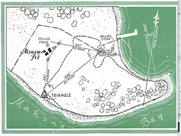
Fig. 2 Stone Triangle on Oak Island in 1939 (Popular Science 06/1939)
The third marker used to mark the location of the du Casse booty is a stone triangle that was located on the Southeast corner of Oak Island. This stone triangle was depicted in the June 1939 issue of Popular Science (Fig 2). The stone triangle was destroyed by Robert Dunfield in the 1960s while he was searching for hidden treasure. A duplicate of the stone triangle has been built that can be seen in the episode, Rock Solid, of Season Six of The Curse of Oak Island, which includes Dr. Travis Taylor. The stone triangle is described as just South of the Money Pit and can be seen as a possible confirmation of Dr. Taylor's theory. From this third marker the booty was buried on a line of magnetic North 190 yards from the stone triangle. The mnemonic "Le Lionceau de Talmont" has 19 characters and the treasure was buried 190 yards on a magnetic North line from this marker. If you can figure out where the original stone triangle was located it would be the third marker Admiral du Casse used to find the hidden booty.
The Halpern Map was written around 1700 and the deviation for magnetic North was about 11 degrees West of true North on Nova Scotia. By using three separate markers Admiral du Casse made sure he would have at least one marker to locate his hidden treasure after his return or the arrival of his son-in-law, Louis de La Rochefoucauld, Marquis de Roye.
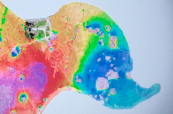
Fig. 3 Magnetometer view of Eastern side of Oak Island with possible treasure locations marked in pink (screen shot from The Curse of Oak Island)
On the magnetometer view of Oak Island in Figure 3 you can see a couple of locations where the soil has been disturbed approximately 190 yards north of where the original stone triangle was located. If previous searchers used a true North heading from the stone triangle they would have missed the hidden treasure Admiral du Casse may have deposited on Oak Island. If you searched along the True North line from the stone triangle they would have failed to find the hidden booty left by Admiral du Casse. I hope hidden treasure still awaits discovery along the magnetic North line of 1700 from the third marker. Since we can't be sure of its original location we can use one of the two other markers on Frog and Round Islands to find the magical X spot on Oak Island.
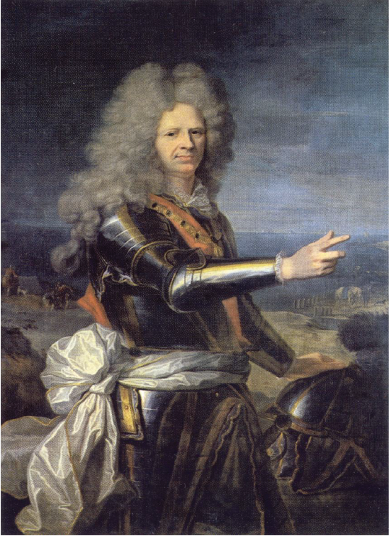
Fig. 4 Admiral Jean-Baptiste du Casse
by Hyacinthe Rigaud (c. 1700)
If the treasure was buried on Oak Island before 1700 another clue may be found in Fig 4. In Fig 4 Admiral du Casse's right hand is aligned with the horizon in his portrait. Currently there are different tricks to determine angles using the spaces between fingers as a measuring tool. Looking at the Admiral's right hand he may be signaling to us the depth of the hidden treasure. I'm not sure what measuring standard he was using but, I feel that he is trying to signal to us a depth or a distance correction he used to tell us where his treasure may be hidden.
Thanks,
Bill McNulty
© 2023-2026 Bill McNulty All Rights Reserved